Los Organos hike from Aguamansa - Tenerife, the diverse island - 3
Canada Blanca hike, drive to Costa Adeje and the lost place Sanatorio de Abona
Arenas Negras hike and stops at the Piedra de la Rosa and the observatory
Sunrise in the Anaga Mountains and a missed sunset at Playa de Benijo
Cruz del Carmen and the coastal hiking trail to Casa Hamilton
Hiking at Mirador de Samara and another visit to the south coast
Long time exposures at the sea and another drive through Teide NP
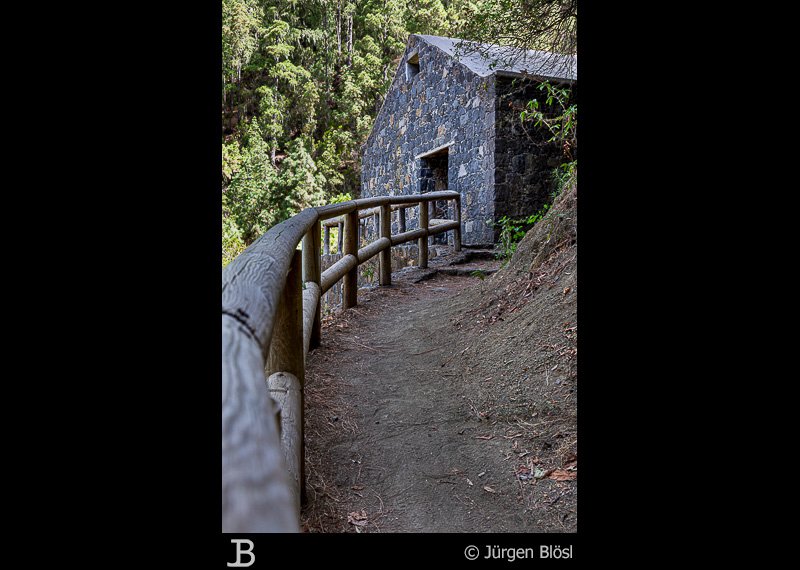
Tue, 7th Sept. - Los Organos hike from Aguamansa
Freya managed the stairs yesterday evening pretty well. We want to start with an easy hike to see what her body is able to handle. From Aguamansa there is a short trail to the base of Los Organos that we want to try. At 5.2 km and about 200 meters difference in height, it seems like a good option.
I brought along our Garmin navigation device and have already entered the address of our trailhead. Everything is going well until Bärbel, as we call our navi, asks me to turn left. This "road" is super steep and narrow - and of course not a one-way street. In the middle of the road, a car comes down. Somehow, we manage to get past each other.
First lesson of the day: Trust the official road signs rather than the navigation system. The way might be longer, but it will save you quite some nerves.
We park on the side of the road, put on our trekking shoes, and walk the road back to the trailhead. Is this steep path really the right way? The posting is clear and there are also some kind of stairs. It is not dangerous or difficult, but our idea of "easy" is somehow different. The steps are uneven, and you have to watch where you put your feet. For me, this is not a problem, but Freya struggles with these conditions from the beginning.
Finally, we reach an asphalt road and follow it for a while. Then we turn right and follow a typical hiking trail upwards. Again, nothing complicated, but quite steep and uneven. Freya needs to focus on where to step and cannot really enjoy the walk. In the end, we even miss a turn and follow a path that ends two meters below the main road. Funnily enough, climbing over the rocks to the path was the part that Freya enjoyed the most.

We are now on an easy-to-walk forest road and decide to rather extend the hike to the caldera and from there back to Aguamansa rather than take the designated trail with narrow paths.
The way to the playing ground in the caldera above the village of Aguamansa is super easy and Freya starts to relax. But then the way down from the caldera is again a path through the forest. Now Freya refuses to go any further. I ask her if I should get the car and collect her, but instead, we just follow the road down the mountain to Aguamansa.
This easy hike was obviously too much for Freya. After the stairs up to the hotel yesterday, she thought that she would be in much better shape. Interestingly, it's her knees that are causing problems rather than her back. But anyway, she's glad to be back in the car.
Connecting the Garmin to the car, we realize that it is not recharging. This is annoying because the only charging cable I have with me is the one for the cigarette lighter. Well, then we have to find our way old-school - with a map. If in doubt, we can always use Google Maps on our phones. It's just a little inconvenient since I don't have a holder for the phone with me.
This morning I saw a big supermarket where I want to buy beer and other things quickly. After some searching, we realize that our Garmin must have taken a different highway exit on the way back. So, I bring Freya back to the hotel and try to find the way from this morning. That works out well and with some snacks and a good cold beer (Dorada Especial), I return to the hotel.